The Island Where the Only Way In Is a Footbridge and the Only Way Out Is the Tide
Holy Island's causeway vanishes twice a day, and the timetable that governs everything there is written by the moon — which is exactly why it's worth the trip.
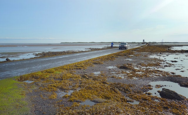
The Northumberland coast road runs flat and empty toward a low line of dunes. Then the road dips, the tarmac narrows, and you notice the poles — tall, thin, planted in the sand at intervals, each one carrying a small box near the top. Those are the refuge boxes. They are there for the drivers who misjudge the water, and in this part of England that happens about once a month, according to holy-island.uk. A car gets written off and an expensive rescue is launched, all because someone tried to race the tide.[4]
This is the causeway to Holy Island, also known as Lindisfarne, in Northumberland, England. It is a normal road that carries commuter vehicles and flat-bed lorries at the national speed limit of 60 mph, per holy-island.uk — until the sea takes it. The island is cut off from the mainland twice a day during high tide, when the causeway is submerged in parts or entirely.[4][5][6]
Five Hours On, Five Hours Off
The rhythm is roughly this: the causeway is usually passable for around five hours either side of low tide, and closed for roughly five hours either side of high tide, according to Visit Northumberland. The default safe crossing time assumes the road is not passable up to two hours before high tide and three hours after it, adjusted for the projected tide height — which on this coast ranges between about 3.5 metres at a very low tide and 5.5 metres at a very high one, per holy-island.uk.[4][6]
That window is not fixed. It shifts every single day, so the current tide table matters more than your memory of last summer's visit, and the recommended crossing windows build in a safety margin either side of the tide. Safe crossing times are published by Northumberland County Council, and Berwick-upon-Tweed Tourist Information Centre carries full details of both the tides and the bus service to the island.[1][6]
Miss the window and you don't argue with the sea. You wait — roughly half a day — or you find a bed. Visitors are advised to leave plenty of time to get off the island safely unless they're staying overnight.[6]
About once a month a driver attempts to race the tide and gets stuck, with their vehicle written off and an expensive rescue launched.
What the Crossing Actually Feels Like
There is a second, older route: St Cuthbert's Way, a foot-only crossing of the sands marked with poles, according to islandeering.com. That is the walk the brochures don't lead with, and it is the one that makes the island feel earned. The surface is sand and mud, the wind comes off the North Sea without much in the way of interruption, and the poles are your only navigation.[7]
If you're driving the road instead, know that the causeway also has deer on it — there is increased deer activity on the causeway road, especially at night and in low visibility, with cars hitting deer in the past year, per holy-island.uk. Closed-toe shoes with good traction are the sensible default on any tidal crossing; the U.S. National Park Service gives exactly that advice for the gravel bar out to Bar Island in Maine, where most trail surfaces are very unlevel.[3][4]
For scale on how quickly these windows close: at Bar Harbor, the gravel bar to Bar Island is exposed for 1.5 hours before and after low tide, and if you lose track of time on the island it is nine hours until the bar emerges again. The walk is half a mile out, 1.9 miles round trip with the trail, and takes 45 to 90 minutes.[3]
The Other Candidates, and Why This One Wins
Britain has a small industry of these places. St Michael's Mount in Cornwall is reached by a historic cobbled causeway at low tide, a 10-to-15-minute walk from Marazion beach, per islandeering.com; its causeway is exposed for around two hours either side of low water, and the opening times shift by roughly 45 to 60 minutes every day, according to the travel blog Biggsy Travels. Burgh Island in Devon is linked to Bigbury-on-Sea by a sandy tombolo at low tide, or by a high-wheeled sea tractor when the tide is in — a 5-to-10-minute walk at low water.[7][11][13]
But the framing of "only way in is a footbridge, only way out is the tide" fits Lindisfarne best, because the crossing is long, the water is real, and the island has a full-time population whose day is structured around it. Eilean Donan in the western Highlands is connected to the mainland by a footbridge, per a travel roundup, but it sits about half a mile from the village of Dornie and the crossing isn't the story. On Holy Island, the crossing is the story.[2]
Plan Around the Water, Not the Weather
The single most useful planning decision is which tide you want. A low tide in the middle of the day gives you a conventional day trip; a low tide at dusk gives you the thing people actually remember — the causeway emptying as the light goes, the water narrowing to a thread and then gone. The trade-off is that you'll be walking back in the dark, on a road with deer on it.[4][11]
St Michael's Mount offers a useful template for how to time it: arriving 15 to 20 minutes before the advertised causeway opening lets you watch the Mount fully cut off as the water narrows and disappears, according to Biggsy Travels, and many people take off their shoes and socks and paddle across while the water is still three to four inches deep. The same instinct works on the Northumberland sands — get there early, watch the sea give the road back.[11]
Book accommodation on the island if you can. Staying overnight is the one way to be there when the day-trippers have been flushed off by the tide, and it turns the schedule from an obstacle into the shape of the visit.[6]
A Culture Built on the Clock of the Sea
Tidal islands have attracted religious communities for centuries — Mont-Saint-Michel in Normandy, with its Benedictine abbey, is the obvious example — and they have been fortified for the same reason, the tidal channel acting as a natural barrier, per Wikipedia's overview. Lindisfarne fits the pattern: a place that was hard to reach on purpose.[8]
Burgh Island shows the commercial version of a tidal-island economy: its sea tractor, designed in 1969 by Robert Jackson CBE and the only one of its kind in the world, is primarily reserved for hotel guests, though non-guests can ride it to the island's restaurants for £2 each way, per the hotel.[14]
What visitors should respect is simple. Don't drive past a closed sign to see if it's really closed. Don't treat the refuge boxes as a photo opportunity. And don't ask a local to estimate the tide for you — check the table, because the exact window shifts every day.[4][6]
The Constraint Is the Point
Most destinations are designed to be photographed. This one is designed to be left. The island tells you when to arrive and when to go, and in doing so it removes the thing that ruins most trips: the assumption that you can do it all. You get five hours. You walk the sands or the road, you see the priory, you eat, and then the water comes back and settles the argument.[6]
The way to keep it that way is to stop treating the tide as an inconvenience to be optimised. Don't book a tight onward train. Don't plan a second stop the same afternoon. The people who get stranded are the ones who thought they could beat a schedule set by the moon — and the sea, as holy-island.uk notes with some understatement, does not negotiate.[4]
Sources
- 9 awesome places you can only visit at low tide - Wanderlust — wanderlustmagazine.com
- Top 10 Mysterious Tidal Islands around the World - Travel Guide 2024 — youtube.com
- Hike Bar Island Trail (U.S. National Park Service) — nps.gov
- Crossing Holy Island’s Causeway: Tips, tides and safety – Belvue Guesthouse Holy Island — holy-island.uk
- Lindisfarne - Wikipedia — en.wikipedia.org
- The Holy Island of Lindisfarne | Visit Northumberland | Visit Northumberland — visitnorthumberland.com
- Discover the Magic of Tidal Islands. - Islandeering — islandeering.com
- Tidal island - Wikipedia — en.wikipedia.org
- Wikipedia: Causeway — en.wikipedia.org
- St. Michael's Mount tide times — cornwall-tides.com
- Crossing the causeway to St Michael's Mount – Biggsy Travels — biggsytravels.com
- St Michael's Mount Causeway – St Michael's Mount — stmichaelsmount.co.uk
- Burgh Island — South West Coast Walk — walksouthwestcoast.co.uk
- The Sea Tractor | Burgh Island Hotel — burghisland.com
Reported with AI assistance using internet sources.